
Mount Vernon Past-Resident Sources
Previous residents of one Mount Vernon address must be reconstructed from overlapping records. Start with the source closest to the target period. Modern ownership begins with the Assessor and Auditor. Printed directories can identify named occupants, including some who did not own the parcel. Census schedules add household structure at long intervals. Permits and maps date the building itself.
| Source | Years It Covers | Where Held | What It Shows |
|---|---|---|---|
| Current recorded-document index | 1973-present | Skagit County Auditor online | Recorded parties, dates, instrument types, and legal descriptions |
| Historic recording search | Interface says 1942-1976; office description says 1942-1973 | Auditor search and office | Surname-initial, role, date, and AFN clues |
| Skagit and Polk directories | Verified volumes from 1882-2004, with large gaps | State Library and SVGS | Names tied to dated addresses |
| Federal census | Individual schedules through 1950 | NARA and library databases | Households and varied personal details |
| Mount Vernon permit notices | Dynamic coverage; verify in portal | City Building and Planning | Address, project, applicant or contractor, and dates when shown |
For a recent sale, begin with the parcel card and current deed. For the mid-century period, combine the deed index with Polk volumes. For an early address, use the State Library catalog, census, newspapers, Historical Society, and the single verified 1890 Sanborn map. An absence in one source never proves that nobody lived there.
Fix Mount Vernon Resident Parcels
The Skagit County Assessor Property Search accepts Address, Parcel #, Owner Name in last-first order, Road, and XrefID. Open the parcel's Summary, Transfers, History, Permits, Map View, and other tabs. Copy the parcel number, situs address, legal description, current owner, and any auditor file number, or AFN, that points to a recorded instrument.
Situs means the physical property address. The owner mailing address is where tax mail goes and can be elsewhere. Neither field lists every occupant. If two records spell the road differently, the parcel and legal description are safer bridge keys than the name alone. Mount Vernon handles addresses inside city limits; county Address Management covers areas outside the city and within its assigned jurisdiction.
Start clean. Copy the legal description and AFN before searching the deed chain; they separate the land from shifting street labels.
Trace Mount Vernon Past Owners
The Skagit County recorded-document index is the core ownership trail. A deed names a grantor, the party giving an interest, and a grantee, the party receiving it. Search the current owner's purchase first. Then turn the seller into the next grantee search and repeat. Use the advanced recording search when a parcel, legal description, permit, tax number, or PLSS field will narrow a common name.
- Pull the current parcel, owner, and legal description from the Assessor.
- Find that owner's purchase deed and record its AFN, date, grantor, and property text.
- Search the seller as grantee to find when that person acquired the same land.
- Repeat while the legal description remains consistent, resolving name variants as they appear.
- At the online cutoff, contact Auditor Recording for the historic index, deed books, copies, or certified records.
- Grantor and grantee
- The party giving an interest and the party receiving it.
- Chain of title
- The linked sequence of recorded transfers for the same land.
- Legal description
- The land's formal lot, block, plat, or metes-and-bounds identity, which can survive an address change.
The current search reaches 1973 forward. The historic screen labels 1942-1976, while the Auditor's description says 1942-1973. Confirm that overlap with Auditor Recording before treating a missing result as proof.
Mount Vernon Previous-Resident Indexes
The current and historic recording searches work differently. Current records can be narrowed by party, document type, date, AFN, parcel, and legal fields. Historic searching relies more heavily on grantor or grantee role, surname initial, year, date, and AFN. That difference is an insider detail worth preserving in a research log.
| Index route | Best starting fields | Main caution |
|---|---|---|
| Current, 1973-present | Last First Middle, role, document type, date, parcel, or legal text | Online images may be unofficial or unavailable |
| Historic | Role, surname initial, year, date, and AFN | Published coverage labels disagree at the boundary |
| Auditor office | Known AFN or legal description | Ask for a complete or certified copy when needed |
The advanced interface is shown below:
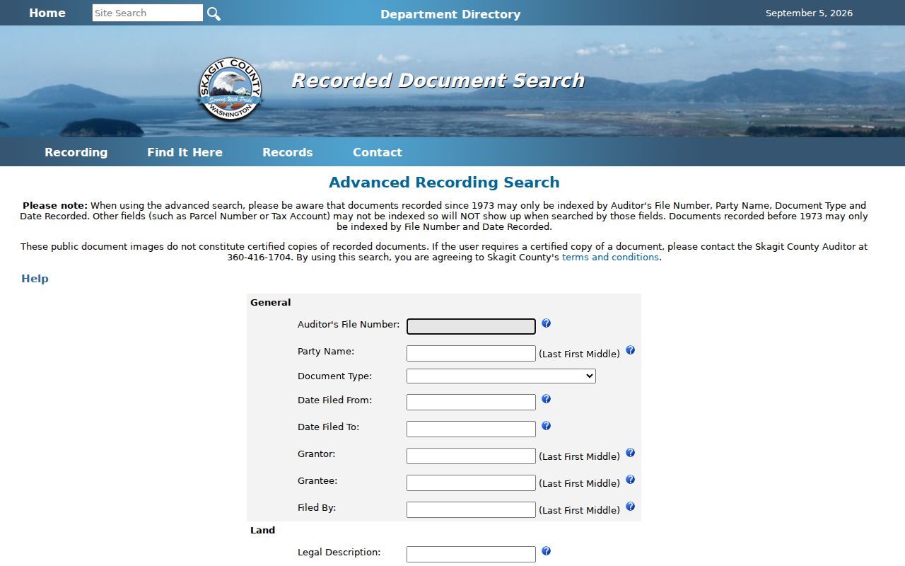
Use it to locate an instrument, then confirm the record with Auditor Recording rather than relying on a search-result line alone.
Mount Vernon Occupants Between Deeds
Ownership and occupancy are not the same. Polk-style reverse directories can list adult names under a street and house number, while the alphabetical section may add a spouse, occupation, business, or telephone. The verified Skagit directory years are discontinuous, so consult the Mount Vernon city directory collections for exact holdings rather than assuming annual coverage.
Pair the records in this order:
- Find the address in a reverse directory and copy every printed name exactly.
- Check each name in the alphabetical section and save the edition's abbreviation key.
- Compare the nearest 1930, 1940, or 1950 census schedule.
- Match owners against the deed chain and occupants against newspapers or probate.
- Log each source date so a later move is not mistaken for a conflict.
The latest public full census is 1950 under the 72-year rule. Most 1890 schedules were destroyed nationally, which makes newspapers, directories, land records, and the Sanborn map more useful for that period.
Date Mount Vernon Resident Buildings
A resident trail is easier to interpret once the building's age is known. The Library of Congress Mount Vernon Sanborn map is dated July 1890 and contains one sheet. It shows built geography, not occupant names. Compare its footprint and street labels with plats, deeds, and later parcel records. No other official local Sanborn year was located in the research.
The city's permit notices can add address-dated project evidence, including a permit or project number, address, applicant or contractor, date, and status when the live system exposes them. A contractor is not necessarily an owner or resident. The capture below preserves the public search entry:
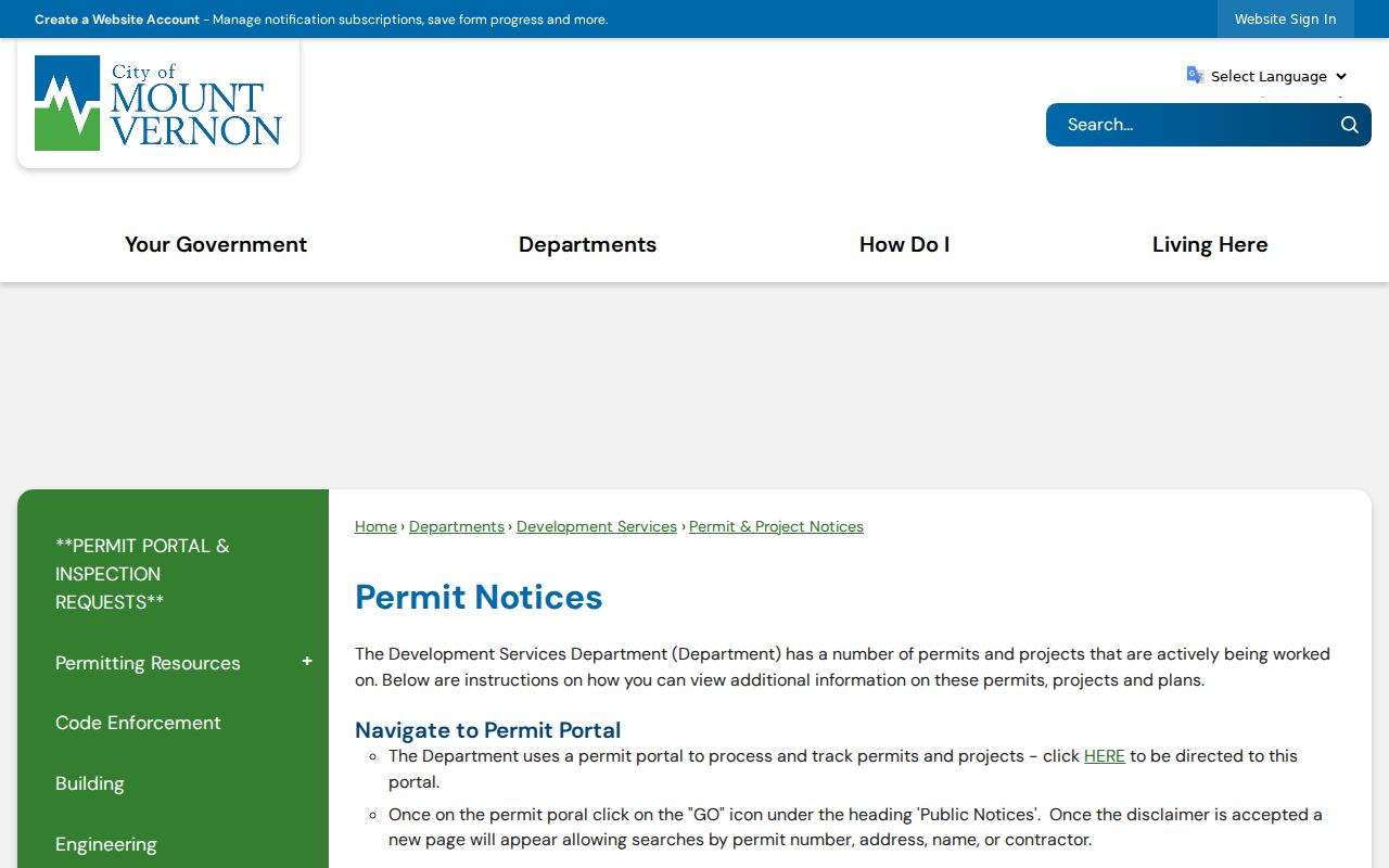
For a missing permit, contact the City Building Division or make a narrow public-records request identifying the address and date span.
Bridge Mount Vernon Past Addresses
No verified Mount Vernon street-renumbering year was found. Do not invent one when an old number differs from a modern parcel. Search both street forms, check the city or county addressing authority, and translate the record through parcel, plat, legal description, and PLSS data. PLSS means the Public Land Survey System's township, range, and section framework.
County Address Management reports that its 2021-22 aerial and spatial project improved address-point accuracy from about 300 feet to about 13 feet and linked addresses with parcels. That was a data-accuracy project, not proof of citywide renumbering. Old GIS points, rural routes, postal wording, and city-limit changes can all create mismatches.
Note: A legal description can preserve identity when a Mount Vernon house number or road label no longer matches.
Archive Mount Vernon Resident Gaps
The Mount Vernon Library Commons offers current newspaper and digital research access. SVGS documents reference books, microfiche, interlibrary loan, and volunteer help. The Skagit County Historical Society adds maps, plats, photographs, letters, clippings, organization records, church materials, ledgers, and oral histories by appointment.
Bring a tight question: one address, all known number variants, parcel and legal description, current and prior owner names, and a date range. Ask whether staff can check a directory year, photograph caption, newspaper item, plat, or organizational file. No formal Mount Vernon house-history service page was found, so contact each repository about its present scope and fees.
Close Mount Vernon Resident Trails
Obituaries and probate files often explain why a name vanishes from an address. Skagit County's historic newspaper index identifies local runs beginning in the 1890s, while the Library Commons advertises more recent databases. A public probate petition, notice, inventory, or order may identify relatives, but restricted details should not be repeated. Request the full public file from the Skagit County Clerk when an index line is not enough.
No city-run Mount Vernon burial database was located. Cemetery and church custodians, funeral-home archives, established cemetery indexes, and Historical Society material are separate routes. Use each obituary as a dated clue, not a present address claim. The result should read as a sourced timeline of previous residents, with unknown years left open.
Lawful use. Research past residents for house history, family history, estate work, or personal curiosity. Never use a public clue to track, contact, or harass a living person.